


 24/7 Emergency Service
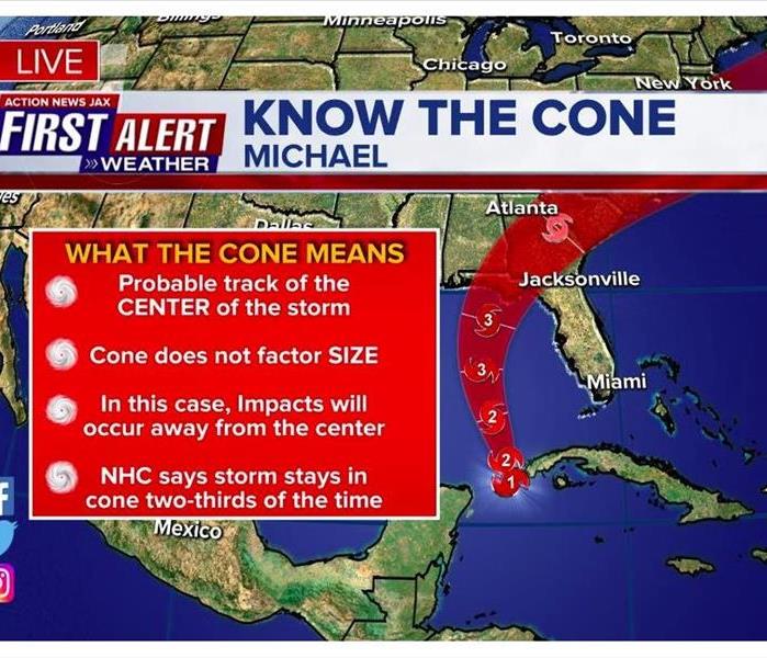
Expected Jacksonville Area Impacts from Hurricane Michael
10/9/2018 (Permalink)
 The Jacksonville area will experience heavy rain in multiple bands through Thursday, with the potential for 1-3" of rain, more in some spots.
Source: Action News Jax
Hurricane "Michael" continues to organize & strengthen. Forecast to hit the Fl. Panhandle as a "major" Cat. 3 hurricane Wednesday afternoon. This could be the most major hurricane to squarely hit the Panhandle since Ivan in 2004 which destroyed the I-10 bridge to Pensacola.
Given current forecast path - SUBJECT TO SOME CHANGES –Michael will hit between Mobile, Al. & the Big Bend of Fl. centered on the Central Panhandle, local impacts for Jacksonville, NE Fl. & SE Ga. are as follows:
* heavy rain in multiple bands through Thu. with the potential for 1-3" of rain, more in some spots. Far more rain just offshore to the east & over NW Fl. & Panhandle into Ga. closer to what should be the center of Michael. Looks like a relative lull in the rain Wed. due to dry slot pivoting north around the eastern side of Michael's circulation.
* breezy winds - combination of "Michael" to the west & moderately strong high pressure to the north will result in brisk winds out of the SE increasing each day through Thu. averaging 15-25 mph with gusts 30+ mph. Strongest winds will be at the beaches & from near Lake City to Waycross closer to Michael's center.
* isolated waterspouts &/or tornadoes, especially Tue. through Thu.
* high rip current risk at area beaches
* minor to possibly moderate flooding - especially at times of high tide - along the coast, intracoastal & St. Johns River & its tributaries due to a combination of strong/persistent onshore flow, occasional heavy rain & an astronomical boost due to the new moon phase. No significant storm surge is expected for NE Fl. & Jacksonville & SE Ga.
If you have have storm damage call SERVPRO of Fernandina Beach/Yulee at 904.729.2401.